Introduction
This is a robust document covering:
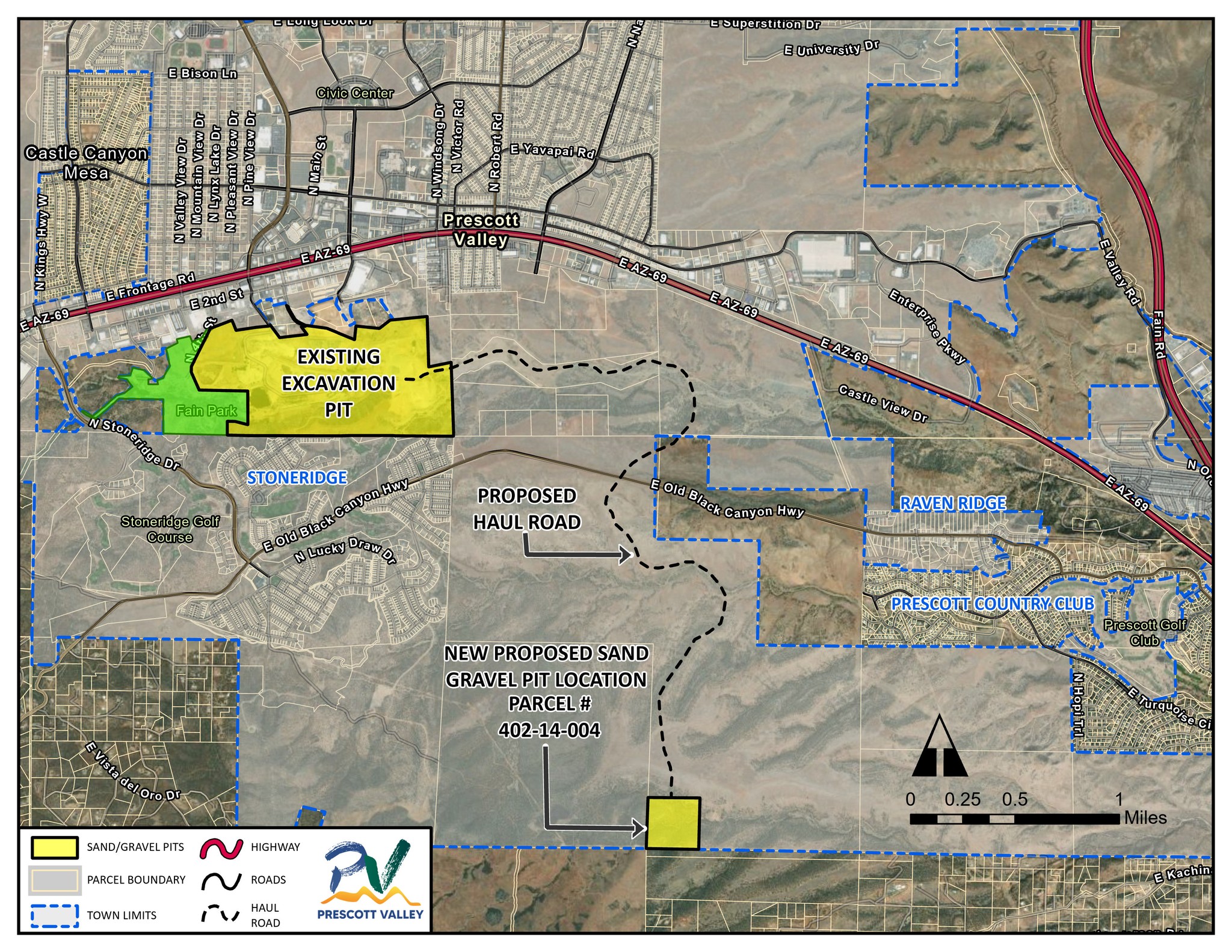
- Existing and Proposed site (“Government Tank”) location
- Water
- Blasting
- Dust
- Home Values
- Trucking
- Why this proposed site?
- Noise
- (2) links to Power Point presentations
- (2) Drone videos showing distances of proposed site from local communities
- Proposed Site versus King Mine
Note: This is a living document and we are continuously updating / editing it as we gather new information and receive new questions to answer.
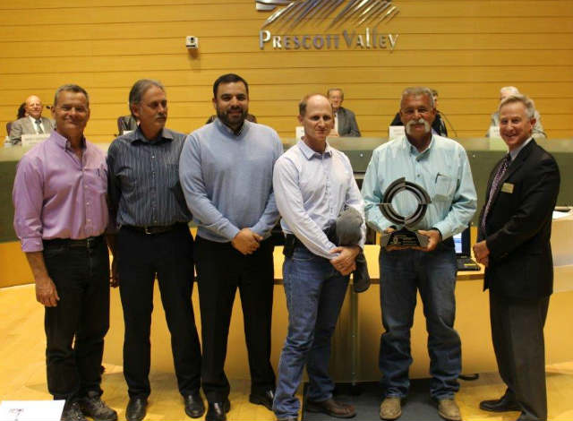
In collaboration with the Town of Prescott Valley, residents of Stoneridge, and community at large, Fain Signature Group has worked diligently to answer many of the questions received from residents regarding the proposed sand and gravel operation.
Water Usage
Will water be used in the operation of the proposed project?
Yes.
What are those uses?
Dust control and processing of material.
How much water will be required (measured in gallons or acre-feet or whatever gauge of measurement you would prefer and whatever temporal parameters you prefer – e.g., Daily/weekly/monthly/annually)?
This is all public record as we report to Arizona Game and Fish as well as Arizona Department of Water Resources. Over the past 25 years, the average usage has been approximately 132.9 acre feet per year. Water usage is dependent upon demand and road/concrete/aggregate material sales. There may be added water usage to mitigate any potential dust on the hauling road, however the actual operations at the proposed site would not increase historical water usage.
Where will the water used by the proposed project be sourced?
Our current source is in Lynx Creek and the proposed operation will use this existing source. A new well will not be drilled at the proposed site or the existing site.
Will there be any on-site groundwater pumping to supply such water?
No. Again, as stated, the proposed site will use the same water source stated above.
Will there be off-site groundwater pumping to supply such water?
No. Historically, there has been no off-site ground water pumping.
Will there be any impact on the water supply for the surrounding housing developments?
No. In the decades of operations at the current site, there has been no recorded or reported impact on the water supply.
Are there any permits that will be needed for the water to be used for the proposed project?
All necessary permits and water rights for the current site and proposed are in effect. If any additional permits / water rights are required in the future, they will be acquired at the appropriate time through the appropriate legal channels.
Blasting
The term “blasting” can be misleading. The current sand and gravel operation that provides materials necessary for regional infrastructure, including local road maintenance, has been going on for decades adjacent to the Stoneridge development. There has been no recorded damage to property of any kind during these decades.
Will the operation of the proposed project involve blasting?
Yes, when necessary. Preferred harvest method is to use machinery and blasting is only used when required.
What will be the likely frequency of blasting events?
Blasting will be completed as needed. Currently, the project anticipates blasting to occur 2-5 times/year if necessary. The duration of blasting is over several weeks which includes set-up and preparation for the blasting.
When during the day will blasting events occur?
Operational hours are Mon – Sat, between 7am-7pm. This is not an all-day event. Blasting typically takes only five (5) minutes.
Have you determined the decibel level at various distances from the blast site? If so, what are those decibel levels? If not, do you plan to do so? A licensed blasting contractor will be utilized, and all regulations will be adhered to include monitoring. The licensed operator is required to operate within the specified standards.
Have you determined the seismic impact of a blasting event at various distances from the blast site? Do you plan to do so?
Seismographs will be in place during blasting as required. In the decades that this operation existed adjacent to the Stoneridge development, there have been no recorded events involving damage of any kind.
Have you consulted any experts concerning either the decibel levels or the seismic impact of blasting events?
Yes, just like past blasting operations adjacent to the Stoneridge development which have only taken place only once in the last 10-20 years, a licensed blasting contractor will be utilized, and all regulations will be adhered to including monitoring at the new, proposed site. Again, during the decades of sand and gravel operations adjacent to the Stoneridge development, all sound levels and seismic levels have been within required levels.
Do you plan to consult with experts on these topics?
Yes, as a part of current operations, a licensed blasting contractor will be utilized, and all regulations will be adhered to including monitoring by industry experts.
Crystalline Silica Dust
Expert Reporting – Respirable Particulate
by Dr. Tem Fugit, 08–7-2025


Air quality monitoring is performed on a regular basis at our current location and will also be at the proposed site according to ADEQ regulations regarding the questions below. It is important to note that while levels of crystalline silica in the air, such as those workers may be exposed to, can have adverse health effects, there is no evidence that exposure to low levels of crystalline silica in the air such as those that residents may experience has any adverse health effects. Workers are continuously tested and monitored by air quality regulations to ensure employee safety.
What measures will you adopt for suppressing the crystalline silica particles from escaping into the ambient air?
Dust control measures will be in place which include equipment filters and water trucks. All current health and safety standards are followed.
Have you consulted with any experts concerning the potential adverse impact of crystalline silica particles on the health of persons who reside at various distances from the proposed project?
Air quality monitoring is performed regularly. Crystaline silica levels will also be monitored and kept within acceptable regulated limits.
Have you applied to the Arizona Department of Environmental Quality for an air quality permit?
We are not at that stage of the process. A permit is applied for after zoning.
Other
Home Values
Have you compiled information concerning the potential adverse impact of the proposed project on the value of the homes in surrounding neighborhoods and developments?
The current operations have been in operation for over 50 years. Looking at the last 20+ years, the average home values are listed below. Note, the average home value in Stoneridge has increased by about 200.5% from 2003 to 2025. The compound annual growth rate (CAGR) for StoneRidge homes from 2003 to 2025 is about 5.2% per year.
The first data set below is sourced from Homes.com, Redfin, Zillow, FRED, FHFA All-Transactions House Price Index for the Prescott Valley–Prescott, AZ MSA, Town/plat history proving.
The second data set below (very similar to first data set) is source from Yavapai County.
Stoneridge Doing Well!
Home value comparison (Yavapai County source): County wide, Dewey-Humboldt, Prescott Valley, Prescott Country Club, Stoneridge (Dark Blue, top line), Prescott.

Multi-source Data Set II – Media Home Price Stoneridge
Notes:
-
2004 (early sales years): ~$232k (index-scaled estimate)
-
2006 (bubble peak): ~$351k
-
2011 (post-crash trough): ~$207k
-
2020 (pre-pandemic baseline): ~$394k
-
2022 (surge peak): ~$564k
-
2025 (anchor): $625k (Jul 2025 median sale price)
Sources: Homes.com, Redfin, Zillow, FRED, FHFA All-Transactions House Price Index for the Prescott Valley–Prescott, AZ MSA, Town/plat history proving.
Yavapai County Data Set II – Media Home Price Stoneridge

Trucking
Will the operation cause traffic/trucks on Old Black Canyon Highway?
Trucks will not drive down Old Black Canyon Highway. Equipment will only cross perpendicularly over Old Black Canyon Highway at one designated intersection. Flagging personnel will be at the crossing when trucks are in operation.
Site
Why was this site chosen?
Working in collaboration with the town and county, it was a goal of the parties to find a source that was further away from the residents than the current source, which at its closest location is between 560’ and 800’. This was the only site in which no public roads would be required for trucking of the material to the processing operation.
Material from a site in a remote area was tested. This site met requirements for the material needed by AP&S and the need for a location that is away from residents.. The Govt Tank site is approximately 8,000 feet from Stoneridge and 6,200 feet from PCC and 2,500 feet from Blue Hills. Other sites under consideration did not meet criteria for testing which include proximity to current sand & gravel operations and proximity to current processing operations in Lynx Creek. (Clarified August 2025).
Will I see or hear this operation from my home?
Not likely. The proposed site is approximately 8,000 ft from the nearest Stoneridge residents. The current site is much closer at approximately 560’ from the closest homes in Stoneridge. The proposed site is also located down in a ravine which will keep it out of line-of-site and direct noise exposure.

Powerpoint Presentation Parts I & II
Below are links to Part I & II of an in-depth powerpoint presentation created by Stoneridge residents.
[Powerpoint presentations are being updated and will be back up shortly]
Site Video I – Long version (10 minutes)
Site Video II – Short version (4 minutes)
Does this site pose the same public health & safety concerns as the Iron King Mine and Humboldt Smelter?No! The borrow pit proposed is NOT a mining operation. It is classified as an Alluvial Gravel Pit. This site has been in existence since 1983. It will be used as a pit from which hard rock is taken for use at another location for the excavation and crushing of rock only. This pit will not pose the health and safety dangers that the Humboldt Smelter and Iron King Mine present. The borrow pit will not use ANY chemicals and will only excavate and crush rock. Due the recent press on the Iron King Mine and the declaration of the former site as a Superfund Site, we wanted to clear up any confusion and draw a comparison between the Iron King Mine and the proposed Borrow Pit and Zoning Request for sand and gravel. Please see the chart below that describes the differences between the two operations:
| Health and Safety Risks | Iron King Mine | Government Tank Borrow Pit |
| Mining | YES | NO |
| Tunneling | YES | NO |
| Smelting | YES | NO |
| Waste/ Tailings | YES | NO |
| Toxic chemicals used | YES | NO |
| Beryllium | YES | NO |
| Lead | YES | NO |
| Zinc | YES | NO |
| Copper | YES | NO |
| Gold | YES | NO |
| Silver | YES | NO |
| Arsenic | YES | NO |
| Groundwater contamination | YES | NO |